4.1
4.2
4.3
4.4
4.5
4.6
4.7
4.8
4.9
4.10
4.11
4.12
4.13
4.14
4.15
4.16
4.17
4.18
4.19
4.20
4.21
4.22
|
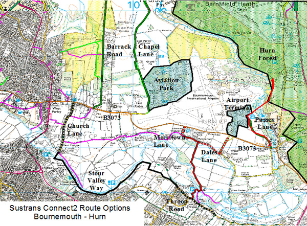
BL of Bournemouth Borough Council (BBC) believed the proposed route, ‘Route 2’, would best link employment and leisure areas to population centres. Transport Plans for Poole, Bournemouth and Christchurch want to increase walking and cycling, and to reduce carbon dioxide emissions. The Route 2 has bus linkage along Castle Lane. The scheme would help achieve modal shift.
Historically, a right of way exists across the River Stour, providing a direct north - south route. The fords at Throop were lost during flood alleviation works. BL and RH reported that about 80 horse riders on the Throop side were effectively stuck.
AR of Sustrans said that the Connect2 scheme was conceived to provide links between communities. By creating suitable crossings to overcome busy roads and rivers, communities are linked to walking and cycling networks. As a result, people will be able to walk and cycle more for everyday journeys. This scheme was made possible through the enormous popular support by the public in the Lottery Vote in December 2007. In addition, the scheme meets the Government’s agenda for transport nationally.
DF of DDC reported he was the Member that represented Hurn parish. DF was unhappy about the threat of urbanisation. DF said that the area still floods, and was concerned that the proposed route, Route 2, would need to be built above the flood level, to maintain passage. In addition, any lighting of this route would not be suitable.
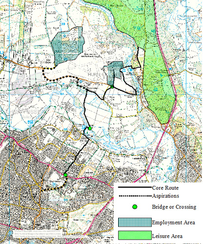
MP of Hurn Parish Council (HPC) had concerns about the Route 2. Principle employment areas are in the north sector of the airport, and would not be served. In addition, the proposed access north to Hurn Forest would need to pass sensitive wildlife areas. In addition, MP felt it would be close to the end of the airport runway and that plane noise would frighten any horse, and such an occurrence is unacceptable. MP highlighted the concerns of flooding. The recently suggested route, which incorporates the ‘Stour Valley Way’ (SVW) to the west, would avoid these issues. MP felt that this route would provide good connections the employment areas.
PT of West Parley Parish Council (WPPC) had doubts about the SVW route suggestion. PT explained that Church Lane currently experienced considerable vehicular movements, particularly from industrial units and the church (during weddings and funerals). The introduction of horse riders and any increase in traffic would not be feasible. PT reported that the southern end of Church Lane also floods. PT was unhappy that there had not been any consultation about the SVW route suggestion, and that there was no information available. AR said that this option had only been put forward in the last few weeks. If it was to be taken forward, there would be further consultation.
BB of Christchurch Borough Council (CBC) explained that for the past 20 years, the conurbation had continued to develop. CBC supported public access to green spaces, and BB citied that the SVW route would achieve this, linking it to the ‘Dorset Way’ network. CBC resources have been spent on this network, but it needed a bridge. BB said that there was a suitable crossing point at the south end of Church Lane. Therefore, the SVW route would provide the desired linkage, and would be considerably cheaper that the proposed Route 2.
Representing horse riders of Throop and Muscliffe, AP explained that their aim was to achieve a safe route for horses. The Church Lane and Chapel Lane elements of the suggested SVW route would not be suitable, and could remain unused if implemented. AP cited that the proposed Route 2 would give riders the needed access to Hurn Forest. Given that the ‘Pig Shoot’ right of way had been lost at Throop, Route 2 would be welcomed.
JH of Bournemouth Cycle Forum explained that this scheme represented the needs of the ‘voluntary sector’. JH cited that between the urban areas, from Poole to Christchurch, there were gaps in access links north. The concept of this scheme and the proposed Route 2 currently sits both Local Transport Plans of DCC and BBC. JH explained there was now a ground swell of local people who want this to be implemented. Now they have presented local authorities with a sum of £350,000 to do it, after 20 year of need for the link. The voluntary sector expects the link to be delivered.
RM of Bournemouth Disabled Forum was concerned about the portrayal of the flooding at Throop, and how it could be perceived by the audience. RM explained that £50,000 was recently spent on parts of the Stour Valley Way. This had also been affected by the recent flooding but the surface was quickly dry and passable afterwards. RM explained that the area north of Throop was ‘pretty’ and it is where most people want to go. Route 2 would satisfy this and it avoids most houses. It is desperately frustrating that wheelchairs, buggies and prams presently could not follow the existing footpath into this area. RM asked to the audience to empathise with this experience. RM then asked for Route 2 to the Airport now, then to progress later with the Hurn Forest link.
JJ of HPC stated that Route 2 crossed the B3073, and asked if there were any proposed details. AR explained that all crossings would be of suitable quality for walkers and riders, such as a Pegasus crossing. JJ re-iterated issues, including flooding. JJ asked if flooding for part of the year was acceptable, and AA and BL said yes. AA commented that the whole Stour Valley experienced flooding, and it was almost inevitable that the route would be closed at times.
JW of East Dorset District Council reported that this was their first involvement with the scheme and had no remit to comment, only to listen.
RLR of Merritown Farm expressed frustration at not being involved in the early stages of consultation. RLR qualified the flooding concerns already expressed; by explaining that it occurs less now the river had been straightened. RLR explained that when grass does not get the chance to dry out, grass turns to mud. RLR stated that adverse weather conditions would prevent wheeled access to any field route as much as the flooding itself. In addition, RLR expressed surprise that there was no indication of any parking provision. RLR explained that Merritown Farm/Adventure Wonderland was a working farm, and received numerous deliveries and the movements of machinery present hazards. Summing up, RLR reported that he was in favour of public access in principle, which already exists, and would be open-minded to proposals.
Representing the Malmesbury Estate, AF said because the proposed route passed through ‘meadow’ land, farmers would be affected both during the construction phase and thereafter. Accommodation works will be required to minimise the impact on farming. AF stressed the route needs sufficient funding post construction for maintenance. AF sought assurances of local authorities that proper maintenance will be undertaken and asked whether there were any financial or time deadlines to adhere to. If satisfactory undertakings were given for ongoing maintenance, the Malmesbury Estate would accept Route 2.
DM of Hick’s Farm explained that his farm was owned by the council and that it was at the lowest point of the flood plain at Throop. DM reported that the land experienced flooding sometimes, but not all the time, and so was not an issue. DM explained that it had been particularly bad this February, but felt that it was a natural process and explained that it brings beneficial nutrients onto grass land. DM said he supported the scheme, and that BBC’s plans for a nature park for the area were good in his view.
BBC and DCC were asked respectively by the landowners for commitment to the routes’ quality and maintenance. RL and AA both expressed that both councils would commit fully, in their annual budget expenditure programmes in the long term. RLR asked for this to be guaranteed, to which RL reported that it was difficult to achieve in council procedures. AF explained that it had to be clear who had responsibility for maintaining which elements of the route. Essentially, landowners need to know who to ring when the route needs attention. AA said that DCC would be responsible and be the point of contact for landowners. AA confirmed that he fully understood that if the route was not maintained, usage would stop. This would not be in anyone’s best interest, and therefore would not be allowed to happen.
AF asked what status the route would have. AA confirmed that it would be a bridleway. JJ felt that the Stour river crossing needed to be wide for young/inexperienced horses and riders, particularly in the middle of the bridge, with appropriate runoffs at each end. Church Lane residents expressed further concerns towards the SVW route suggestion, for horse and bike riders. They said that the B3073 was currently difficult to cross, and would need the installation of a quality crossing.
MP of HPC said that there were sensitive areas adjacent to the east side of the Airport. MP asked if Dorset Wildlife Trust had been approached. AR of Sustrans explained that Natural England had been involved from the start. They were in favour of the scheme in principle, and had suggested ways to achieve a route.
RW of BBC, representing Muscliffe, expressed frustration at the resistance met during meetings. JF of Throop Cottage believed that this scheme was not getting anywhere, and stated that if the desire for a route had remained for 20 years, then it might be best to come back in a few years and try again. AR said that there was a Lottery funding deadline. The £50M available nationally had to be spent by March 2013. HPC expressed further concern about urbanisation. AR explained that the surface would have a plastic mesh finish which allowed grass to grow, and be mown. The route would be to Greenway Standards, 3.0m wide and have minimal environmental impact. Users are attracted to the beauty of the area, and that must remain.
There was a general appeal to the Chairman to control interruptions. However, the Chairman re-iterated that the purpose of the meeting was to listen to all concerns, and this was part of the process. It was agreed there would be no lighting. MP of HPC said there was an existing route, and was unhappy about further development. RM explained that the existing route was not good enough for wheelchairs and those with prams etc. Other cited bridges as being expensive. There was a general call for engineering input. AR stressed that the scheme was at the conceptual stage, and would progress to design stages in due course, where ground issues would be negotiated. There should be no expectation for detail at this stage deliberately, so that principle issues could be resolved first.
There was general disappointment that, despite an invitation, Bournemouth Airport was not represented at the meeting. MP of HPC said that the airport had concerns about security. RR of Sustrans said that the Airport was planning to revise their security arrangements, and that construction could be phased afterwards.
Asked if a future funding shortfall would compromise the scheme, AR explained that it was by no means unusual to progress projects with initial funding shortfalls, because there are other sources Sustrans that have experience of securing funds from. |